- Single room supplement £90 per person per night (subject to availability)
- Solo traveller supplement £90 per person per night
- Odd number group supplement £90 per group per night may apply if a single room is required
- Extra night prior to the start (single room) £240 per person
- Extra night prior to the start (twin room, needs 2 people) £125 per person
- Extra night at the end of the event (single room) £240 per person
- Extra night at the end of the event (twin room, needs 2 people) £125 per person
- Transfer back to your car at the end of your walk (for up to 3 passengers) £350
- Extra bag £15.00 per person per day
Please select from Optional Extras at checkout.
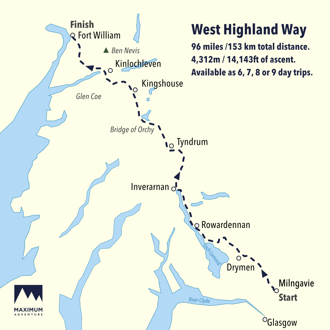
By road: Milngavie is located 25 minutes to the North of Glasgow. There is free parking available for the duration of the trip outside the station in Milngavie or in front of the Police Station.
By public transport: Glasgow is well served by train services from all parts of the UK. From the centre of Glasgow [GLC] there is a regular train service to Milngavie Station [MLN] at the start of the West Highland Way, which takes around 25 minutes. Check traveline.info for the latest public transport information.
By air: The nearest airport is Glasgow International [GLA], from where you can take one of the regular airport shuttles into the centre of Glasgow (20 minutes). From here, take a train from either Glasgow Central Station or Glasgow Queen Street Station to Milngavie Station (25 minutes). Check www.traveline.info for the latest public travel information. There are also excellent public transport links from Edinburgh Airport (EDI]. Take the AIR coach direct from the airport to Buchannan Street Bus Station in the centre of Glasgow (1 hour) and then there is a short walk from the bus station to Queen Street Station, where you catch the train to Milngavie (25 minutes).
Getting Away
To get back to your car: To return to your car in Milngavie, take the train or bus from Fort William to Glasgow Queen Street and change for a train to Milngavie Station. The journey takes approximately 4 hours.
By road: Fort William is located on the A82 on the banks of Loch Linnhe 2½ hours north of Glasgow.
By public transport: There is a public bus or train service from Fort William Station to Glasgow which takes around 3½ hours.
By air: Return to Glasgow via bus or train and take either the airport shuttle to Glasgow Airport or the AIR bus to Edinburgh Airport.
You can purchase evening meals either at the accommodation or nearby. When our event planners send you the schedule with itinerary you could prearrange directly with the accommodation or during the walk.
For lunches we would suggest bringing some of your own favourite snack bars and then asking the accommodation for a packed lunch for the following day and also supplementing that at stops en-route.
Accommodation is generally at B&B, guest houses and small hotels. Once booked in, your event planner will send you a list of your booked accommodation. It is possible to adjust according to preference at this stage so please mention it if you wish to change.
If you would like to bring your four legged friend, then we will do our best to source dog friendly accommodation. There will be a supplement for your dog and there may also be a hotel and taxi supplement payable. Therefore, once booked in, please alert your adventure travel planner that you would like to bring your dog and we can proceed from there.
If you would prefer to have a guide for your walk, even just for one day, then we are happy to help. We can provide a qualified leader (also first aid qualified) to lead your trek or on just one of the sections. Just ask us.
A guide can not only take the stress out of navigation, but you will also find them a great asset in terms of providing an insight into all things environment and nature.
For available dates please see the ‘build your trip’ option on the left hand side on desktops or at the bottom on mobiles. You can reserve your space via this route.
After placing your booking with us, you will in the first instance receive an automated email from our system confirming receipt of your reservation. If you don’t receive it, it is worth checking your spam/clutter folder.
In the process of placing your booking, you will generally set up an access password to our online gateway where you can review the details of the booking.
Your personal event planner will then be in touch with you to start to confirm the details. This contact will usually be taken up in the working day after receipt of your booking, but may, in busy times, take a little longer. The event planner will then liaise with you regarding the details of the course. If you have any specific requirements, please do mention it at this stage.
Unfortunately, all good things come to an end at some point and when you arrive in Fort William, you have one of several options. If you have not booked an additional night’s stay in Fort William then we will deliver your luggage to the Nevis Centre in Fort William. From there you may have onward travel arranged as per the ‘Getting There and Back’ tab above.
Some people like to treat themselves to a night’s stay in Fort William at the end. And why not? You’ve earned it. You can arrange this as an optional add on with your event planner.
Sitting majestically at the end of the West Highland Way is Britain’s highest mountain, Ben Nevis. If you are of the tireless variety, then you may consider climbing this at the end of your trek. We provide regular guided ascents of Ben Nevis and you could either join an open event or book yourself your own personal guide for the day. Please speak to your event planner should this be of interest.